Background and Overview
Clean water is essential to the survival of all living things. The Houston-Galveston area has 16,000 miles of streams and shoreline providing a network of valuable habitat and ecosystem services for the region, connecting freshwater streams to productive coastal estuaries and connecting us to nature and to each other. Clean water is a foundation for our regional economy, contributing $4 billion annually through ecotourism, oyster harvesting, and commercial fishing.
However, more than 80 percent of stream miles within the region fail to meet state water quality standards or screening criteria for one or more parameters. Projected population growth will continue to strain the health of waterways if proper management practices are not established. The Houston-Galveston Area Council (H-GAC) and its local partners are working to improve and protect water quality through the Clean Rivers Program (CRP) and other regional efforts.

The Texas Clean Rivers Act requires river authorities to prepare written water quality assessment reports, such as this Basin Summary Report, for their respective basins and present the reports to the Governor, Texas Commission of Environmental Quality (TCEQ), Texas State Soil and Water Conservation Board (TSSWCB), and Texas Parks and Wildlife Department (TPWD).
The Act also established the Texas Clean Rivers Program, funded by fees paid by wastewater discharge permittees and water rights holders. CRP, under the direction of the TCEQ, requires continuous assessment of ambient water quality to identify key issues and develop management strategies statewide. Written CRP reports submitted to government officials and state agencies provide input and guidance for water resource policy and decision-making efforts.
CRP includes such initiatives as basin-wide water quality monitoring strategies and simultaneous expiration of wastewater permits within watersheds to allow for more coordinated permitting. CRP promotes pollution prevention at its source in order to reduce the cost associated with wastewater treatment and to prevent the need for remediation of damaged ecosystems resulting from pollutant releases.
Results from the CRP process help set the agenda for all other water quality management programs, including: monitoring, standards development, permitting, enforcement, public outreach, and field investigation and research. At the same time, these programs use the basin assessment process to ensure that data needs are addressed and match local priorities. In the end, the underlying goal of the entire CRP process is to most effectively use the public funds targeted for water quality protection.
Clean Rivers Program Objectives
- Provide quality-assured data to state agencies, river authorities, and local governments for use in water quality decision-making.
- Utilize established scientific and statistical methods to evaluate current water quality issues and their relative risks to public health and the environment.
- Evaluate current and historical data to identify where additional information is needed.
- Prioritize water quality issues and problem areas for future studies and implementation efforts.
- Promote cooperative watershed planning and conduct comprehensive assessments that consider a broad range of pollution threats.
- Develop and maintain cooperative partnerships with river authorities, local governments, state agencies, private industry, conservation organizations, and other local and regional entities to improve understanding of current and future water quality problems.
- Use public outreach and education to involve citizens and private organizations in watershed management and protection efforts.
- Provide effective administration and leveraging of funds to maximize effectiveness of watershed activities.
- Adapt program to emerging water quality issues.
H-GAC, an established Council of Governments (COG) and regional planning agency for the Gulf Coast State Planning Region, has more than 35 years of regional environmental planning and public outreach experience. H-GAC continues to develop a comprehensive regional Geographic Information System (GIS) for data analysis and modeling techniques. Many key agencies and individuals normally involved in regional water quality programming already work cooperatively under the umbrella of H-GAC’s existing environmental committees and programs.
H-GAC is designated as the lead agency responsible for regional water quality assessment for the San Jacinto River Basin, Trinity-San Jacinto Coastal Basin, San Jacinto-Brazos Coastal Basin, Brazos-Colorado Coastal Basin, and Bays and Estuaries in this region. H-GAC oversees all aspects of CRP monitoring in these basins with the following tasks in mind:
- Project Administration
- Quality Assurance
- Water Quality Monitoring
- Data Management
- Data Analysis and Reporting
- Stakeholder Participation and Public Outreach
H-GAC’s CRP project staff regularly updates H-GAC’s Board of Directors and Natural Resources Advisory Committee (NRAC) on CRP progress and results. Board approval, is required for major actions, including entry into contracts with TCEQ and TSSWCB, and approval of subcontracts.
H-GAC Clean Rivers Program Steering Committee
H-GAC's CRP is guided by a Steering Committee that serves as the primary forum for discussion of various water quality issues raised during the assessment process. The Steering Committee includes representatives from local government, state and federal agencies, key interest groups, and several members of H-GAC's NRAC. The Steering Committee normally meets two to three times per year depending on project milestones and administrative needs. Meetings allow the Steering Committee to advise H-GAC staff on CRP matters, including:
- Developing work plans and budgets
- Monitoring progress toward project milestones
- Reviewing draft and final basin reports
- Focusing monitoring and implementation efforts to priority areas
- Providing regional perspective and local expertise to the assessment process
- Communicating information between member representative groups and CRP
- Providing opportunities for public comments and questions about CRP activities
H-GAC Local CRP Monitoring Partners
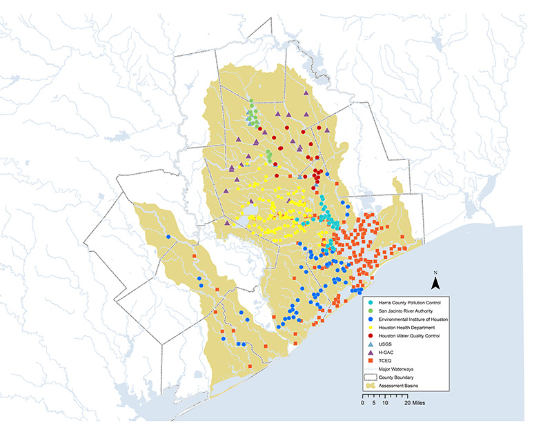
As part of the regional Quality Assurance Project Plan (QAPP), H-GAC works with local agencies to conduct water quality monitoring throughout the region. H-GAC’s CRP leverages program funding for these partnerships, allowing the program to increase monitoring stations and provide additional data that benefits the overall assessment process. CRP partners meet quarterly to discuss monitoring challenges, sampling protocols, equipment problems, and to serve as a forum for sharing information from the TCEQ regarding quality assurance or data management issues. Monitoring sites are funded wholly or in part by CRP. Coordinating monitoring efforts through CRP allows partner agencies to reduce costs by minimizing duplicated monitoring events. These savings can then be reinvested in expanded monitoring, special studies, and other tools to better assess regional water quality.
Partners include:
- City of Houston Drinking Water Operations
- City of Houston Health Department
- Environmental Institute of Houston
- Harris County Department of Pollution Control Services
- Houston-Galveston Area Council
- San Jacinto River Authority
- Texas Commission on Environmental Quality Region 12
- Texas Research Institute for Environmental Studies
- US Geological Survey
The Basin Summary Report (BSR) is produced every five years and outlines water quality issues within H-GAC’s five basins based on public and committee input, as well as technical analysis of historical, current, and projected water quality trends. This work is completed in accordance with TCEQ guidelines, which specify a range of evaluation techniques that achieve a comprehensive assessment of water quality issues within each basin and the region. In years when the Basin Summary Report is not due, H-GAC produces a Basin Highlights Report that contains a summary of activities in the various basins. Past reports can be found on H-GAC’s website.
The BSR complements TCEQ’s Texas Integrated Report of Surface Water Quality. The Integrated Report is completed every two years and describes the status of Texas’ natural waters based on historical data, CRP data, and reports like the BSR. As a result of this report, streams found to be out of compliance with state-designated standards or uses may be placed on the 303(d) list of impaired waters by the TCEQ, potentially triggering additional special studies and implementation efforts to improve water quality.
