Non-CRP Special Projects
Although the H-GAC Clean Rivers Program (CRP) does an exceptional job collecting high quality water quality data, routine monitoring alone is not adequate to demonstrate success in the pollution reduction throughout the region. Other non-CRP special projects focus more on the implementation of best management practices (BMPs) and other efforts to help improve water quality conditions. CRP data may be utilized to accomplish project goals, but CRP does not fund these studies. The following is a list of non-CRP special projects that have been conducted over the past five years.
As part of 604(b) grants from TCEQ, H-GAC maintains a series of wastewater and water quality databases, conducts special studies, and provides various planning services. Examples include a regional OSSF location database, comprehensive wastewater infrastructure databases, outreach materials for small coastal communities, and regionalization feasibility analyses. H-GAC also serves as a regional coordinator of water quality efforts under this project, including facilitation of the Natural Resources Advisory Committee (NRAC).
The Trust for Public Land (TPL) initiated a Greenprint project for the West Fork San Jacinto River watershed in early 2014. The project uses local stakeholder input to develop spatial priorities for land conservation efforts aimed at improving water quality and water-based recreation. H-GAC assisted TPL in communication with local partners and coordinating efforts with the West Fork WPP project. The Greenprint project will conclude in early 2016.
The Gulf-Houston Regional Conservation Plan, facilitated by Houston Wilderness, is the product of a coalition of local entities involved with programs related to land conservation. The RCP represents a coordinated look at conservation and environmental project priorities in the Houston region. The immediate purpose of the RCP is to pursue and inform funding opportunities under the RESTORE Act. However, its long term goal is to provide a comprehensive view of land conservation efforts and priorities in the region.
H-GAC assisted Harris County Flood Control District (HCFCD) in developing high level planning materials for increasing flood mitigation in the Halls Bayou watershed, including the Westfield Estates project area. The Halls Ahead! project drew from local stakeholder knowledge and values to guide planning recommendations for placement and type of flood mitigation practices and informed policy about the approach to obtaining and implementing flood mitigation practices in this watershed.
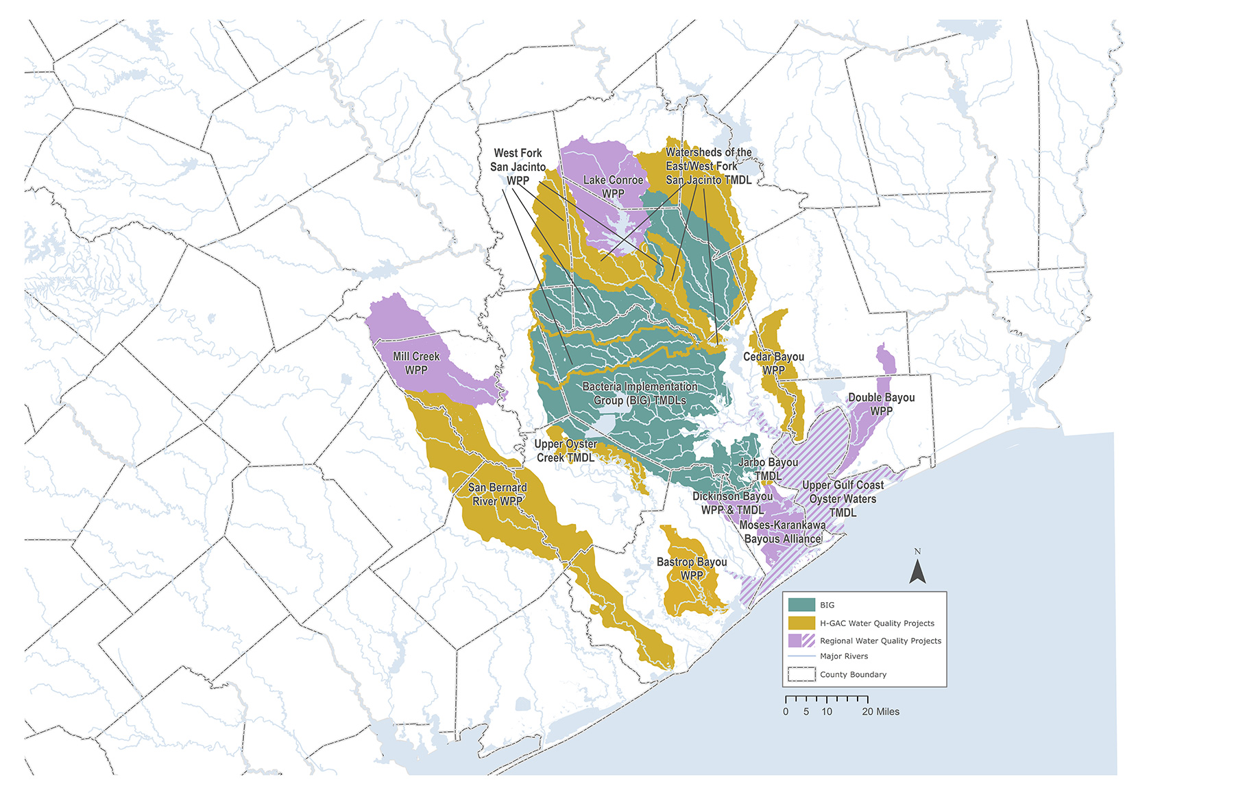
Watershed Protection Plans (WPPs) are initiated when a water body appears on TCEQ’s 303(d) list of impaired waterways. WPPs are voluntary and contain no regulatory requirements.
Westfield Estates - Westfield Estates is a small urban neighborhood directly north of the City of Houston in Harris County. H-GAC worked with TCEQ to produce a WPP for this area, which was completed in 2012. The primary focus of this effort was to reduce bacteria from OSSFs and pets into the open ditches of the neighborhood, where bacteria levels were elevated. H-GAC worked with local partners toward a planned conversion to sanitary sewer, with interim steps of pumping aging OSSFs, educating residents, and promoting pet waste management.
Bastrop Bayou - Bastrop Bayou, in southern Brazoria County, has a watershed that includes portions of Angleton and Lake Jackson. Large cattle populations, high OSSF failure rates, pet waste, and other sources led to elevated bacteria levels in the bayou and its tributaries. Since 2006, H-GAC, TCEQ, and local partners have been working to develop and implement a WPP for this watershed. Current implementation activities include resident education, OSSF remediation, coordination with USDA, NRCS, and TSSWCB on agricultural activities, and installation of pet waste stations at local parks.
San Bernard River - The San Bernard River flows through Austin, Colorado, Wharton, Fort Bend, and Brazoria counties in the western side of the region. Bacteria impairments led to the development of a WPP facilitated by H-GAC and TCEQ, starting in 2009. The WPP identified best management practices to address contributions from livestock, domestic pets, wildlife, OSSFs, and other sources. The EPA and TCEQ are currently reviewing the plan and will provide edits and feedback prior to its completion.
Dickinson Bayou - The Dickinson Bayou watershed is located within the San Jacinto-Brazos Coastal Basin, southeast of Houston and west of Galveston Bay, covering a total of 99.7 square miles. TCEQ determined that some portions of Dickinson Bayou are impaired for both elevated levels of bacteria and low DO concentrations. A WPP was developed by the Dickinson Bayou Watershed Partnership in 2006. The Texas Coastal Watershed Program, under contract with TCEQ, has been coordinating stakeholder involvement, via the Dickinson Bayou Watershed Partnership (DBWP), for development of this WPP. H GAC has been a partner and participant in these efforts. The TCEQ accepted the WPP in May of 2009 and submitted to EPA for approval. The WPP is currently being revised to address EPA’s concerns while TMDLs for bacteria and DO, and subsequent I-Plans are currently in progress.
Cedar Bayou - Cedar Bayou is a direct tributary to Galveston Bay, located at the eastern edge of Harris County. From its headwaters west of Dayton to its mouth near Baytown, the bayou has a variety of water quality issues. H-GAC has worked with the TSSWCB and local partners since 2010 to develop a WPP that addresses high levels of bacteria and other contaminants. The WPP identified best management practices including OSSF remediation, pet waste management, education and outreach, and agricultural programs. The WPP is currently under review by EPA. Stakeholders began implementing aspects of the WPP prior to the completion of the WPP. H-GAC is currently working with TSSWCB to implement select BMPs as of December 15, 2015.
West Fork San Jacinto River - The West Fork of the San Jacinto River and its tributary, Lake Creek, are primary sources of water for the Lake Houston reservoir. This waterway has elevated levels of bacteria and H-GAC is working with TCEQ to address this issue and other stakeholder concerns (sediment, trash, nutrients, DO levels) through a WPP. Concurrently, H-GAC is conducting preliminary characterization studies for Cypress and Spring Creeks, the other two primary tributaries of the West Fork above Lake Houston. This project started in 2015 and will run through August 2018.
Total Maximum Daily Load (TMDL) is a regulatory process triggered when a waterway is placed on the 303(d) list of impaired water bodies. TMDLs calculate the maximum amount of a pollutant a water body can receive while still meeting water quality standards. An Implementation Plan (I-Plan) is then developed to implement the best management practices recommended in the TMDL or preceding WPPs. Superfund sites are areas that are federally designated as being contaminated with hazardous substances and pollutants. The Superfund program uses funds collected from the responsible parties to remediate contaminated sites.
Bacteria Implementation Group (BIG) - In 2008, H-GAC formed the 31-member Bacteria Implementation Group, a group of government, business, and community leaders with a common goal of developing a plan for reducing bacteria in area waterways.
The BIG project area includes approximately 4 million people and waterways in part of 10 counties: Brazoria, Fort Bend, Galveston, Grimes, Harris, Liberty, Montgomery, San Jacinto, Walker, and Waller. With the help of 14 workgroups and additional stakeholders, the BIG completed a bacteria reduction I-Plan in January 2013. The plan includes provisions for an iterative process involving annual evaluations of progress, latest research, and stakeholder involvement. The BIG has begun the implementation phase of the TMDL process and plans implementation activities to be completed over the next 25 years.
The BIG uses Houston-Galveston region CRP data to benchmark environmental progress toward implementation goals as directed in the I-Plan through the production of an Annual Report. All BIG materials are available on the website.
Implementation activities have included stormwater management and physical channel improvements, routine infrastructure maintenance and illicit discharge detection programs, onsite sewage facility inspection programs and repair, replacement and abandonment efforts, and public outreach initiatives related to sanitary sewer overflows from fats, oils, and grease, and proper disposal of pet waste. Bacteria levels continue to decline from almost nine times the state’s contact recreation standard to just above four times the standard in the BIG area.
Upper Oyster Creek - Upper Oyster Creek in northern Fort Bend County is a modified series of waterways with numerous impoundments, supply canal diversions, and other modifications. Its watershed includes growing areas around Sugar Land and Missouri City, southwest of Houston. Elevated bacteria and depressed DO levels were first listed in 1996. TCEQ began the TMDL project to address them in 2002. H-GAC worked with TCEQ and local partners to develop an Implementation Plan (I-Plan) for bacteria and DO. The I-Plan calls for local partners to address bacteria through education and outreach and management of human and wildlife sources of bacteria. The I-Plan was approved by TCEQ in early 2014, and is being implemented by H-GAC and TCEQ.
East-West Fork San Jacinto River - The watersheds included in this TMDL drain into Lake Houston. They include the East Fork San Jacinto River, West Fork San Jacinto River, Crystal Creek, and a western arm of Lake Houston. The Texas Institute for Applied Environmental Research (TIAER) completed a TMDL study in 2014, and H-GAC conducted public and stakeholder outreach activities for I-Plan development by creating a 27-member Coordination Committee in 2014. In 2015, the committee, along with six work groups, determined the watershed comprising the East and West Fork of the San Jacinto River TMDL should join the BIG project area. The Coordination Committee is working with the BIG to complete this process. The TMDL study and plan to join the BIG is with the TCEQ and will be brought to the TCEQ Commissioners for review in summer 2016.
Jarbo Bayou - Jarbo Bayou, located in Galveston County, is a tributary of Clear Lake. Roughly three square miles, it encompasses all of Clear Lake Shores and portions of Kemah and League City. This bayou is currently the subject of a bacteria TMDL and I- Plan process directed by the TCEQ, the University of Houston, and H-GAC. Concurrent with the development of the TMDL, a 14-member Coordination Committee, along with four work groups determined next steps in the TMDL implementation plan process, including joining the BIG project area and implementing the BIG I-Plan. The Coordination Committee is working with the BIG to complete this process. The TMDL study and plan to join the BIG is with the TCEQ and will be brought to the TCEQ Commissioners for review in summer of 2016.
Armand Bayou - Armand Bayou is a tributary of Clear Lake in the San Jacinto-Brazos Coastal Basin. High concentrations of bacteria have been detected in the bayou. As a result, the TCEQ and University of Houston completed a TMDL study. In 2013, a 20-member Coordination Committee decided to join the BIG for cost-savings and quicker implementation of remediation activities. In 2015 the TCEQ Commissioners approved the plan to join the BIG Implementation activities have been initiated by watershed stakeholders.
Dickinson Bayou - The Dickinson Bayou Watershed Partnership (DBWP), facilitated by the Texas A&M AgriLIfe Extension Service (Extension) is working to improve water quality in Dickinson Bayou. \ "The Implementation Plan for Eight Total Maximum Daily Loads for Indicator Bacteria in Dickinson Bayou and Three Tidal Tributaries" was completed and approved in January 2014.
This plan identifies likely bacteria sources, technical and financial needs, monitoring and outreach efforts, and a schedule of activities for each of the stakeholder-developed management measures that will be used to reduce bacteria levels. Key management measures include: managing on-site sewage facilities, improving wastewater treatment facilities and collection systems, addressing animal waste, restoring and repairing riparian zones, preserving and restoring natural wetlands, constructing stormwater treatment wetlands, and implementing stormwater best management practices. There are several ongoing efforts including annual septic system workshops for homeowners, a riparian workshop that was held in February 2015 and a Texas Watershed Stewards course held in July 2015.
The DBWP has explored ways to maintain the organization as its needs transition from planning to implementation efforts. After much research and discussion, the group decided to join forces with other Galveston and Brazoria County watersheds to form a coalition focused on implementing approved I-Plans and WPPs. A grant from the Galveston Bay Estuary Program was obtained as seed money for the Coalition effort which will begin in the fall of 2016.
Oyster Waters - The Upper Gulf Coast Oyster Waters I-Plan, led by the Galveston Bay Foundation (GBF) with support from H-GAC, addresses 11 TMDLs related to bacterial contamination of oysteries in and around Galveston Bay. Eighteen stakeholder organizations and concerned citizens developed the I-Plan which identifies likely bacteria sources, technical and financial needs, monitoring and outreach efforts, and a schedule of activities for each of the stakeholder-developed management measures that will be used to reduce bacteria levels. The I-Plan was completed and approved by the TCEQ in August 2015.
GBF is working with project partners on plan implementation tasks. Implementation has included a Cease the Grease campaign aimed at reducing the impacts of fats, oils, and grease in sanitary sewers and a boater waste education campaign, both of which began in 2014.
Dioxin/PCB Stakeholder Meetings - The Houston Ship Channel/Upper Galveston Bay dioxin and PCB TMDLs are located in the southern portion of the San Jacinto River, Houston Ship Channel, and Upper Galveston Bay. The purpose of the TMDLs is to determine the necessary reductions in PCBs and dioxin within these watersheds needed to meet water quality standards. TCEQ is working with local stakeholders to assist in the development of the TMDLs and subsequent I-Plans.
As a result of stakeholder input, the San Jacinto River Waste Pits were identified as a primary contributor of dioxin to the Galveston Bay Estuary. In 2008, the U.S. Environmental Protection Agency, Region 6, listed the San Jacinto River Waste Pits as a Superfund Site. Subsequent to it being listed, the EPA oversaw the installation of a temporary armored cap to prevent the additional release of dioxins and the placement of warning signage at the site. A feasibility study that includes identification of cleanup alternatives was completed, followed by public comment on the proposed plan for cleanup. In a related effort, the GBF placed seafood consumption advisory signage at fishing locations and boat ramps throughout the San Jacinto River, Houston Ship Channel, and Upper Galveston Bay.
The Dioxin TMDL report is currently under staff review at TCEQ. No date has been set for sending this report out for public comment. In 2014, The University of Houston completed additional PCB monitoring activities in Galveston Bay and modeled the data for inclusion in the PCB TMDL report.
H-GAC has participated in stakeholder involvement and public outreach efforts related to the San Jacinto River Waste Pits Superfund Site. In addition to working with the EPA to provide stakeholder engagement opportunities in conjunction with the Dioxin TMDL project, H-GAC has also collaborated with the Harris County Attorney’s office and other stakeholders to persuade the EPA to proceed with remediation measures and public education efforts pertaining to the site.